Loading...
Loading map...1935 Map of Camden
USGS Topo · Published 1969About this map
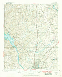
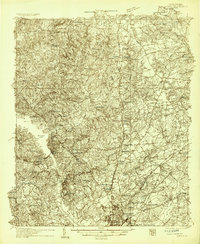
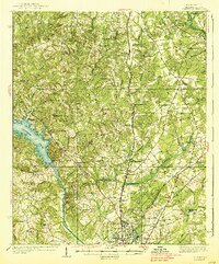
The city of Camden and the recently formed Wateree Lake anchor this mid-1930s landscape in Kershaw County. Following the construction of the Wateree Dam, the reservoir dominates the western edge of the sheet, while the Southern railroad line runs north-south through settlements like Westville and Clyburn. The map reveals a densely settled rural interior defined by family names and community landmarks, from the Smyrls Cem near Kirkland to industrial sites such as Gaston Mill and Barfield Mill on the creeks to the east.
Find a feature on this map
94 named features on this map. Tap any name to fly to it.
Don’t see what you’re looking for? This feature index may not catch every label — zoom into the map to look around manually.
Map Details
Date Portrayed1935
Date Published1969
PublisherU.S. Geological Survey
Map TypeTopographic
Scale1:62,500
Physical Dimensions16.8 x 20.8 inches
Editions of this 1935 Camden Map
2 editions found
Historical Maps of Camden Through Time

Featured Locations
Source Details
SourceU.S. Geological Survey
CopyrightPublic Domain