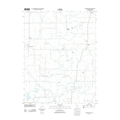
2012 Map of Camden Point
USGS Topo · Published 2012About this map
The Platte River meanders extensively through this Missouri landscape, creating distinctive geographical features like the Goose Neck and Slash Valley. This region of Platte County is defined by its rural agricultural character, with small settlements such as Edgerton Junction, Ridgely, and Kerrville serving as local hubs. The map is a vital resource for genealogical research, documenting numerous burial grounds including Mount Zion Cemetery, McComas Cemetery, and Standiford Cemetery. Transportation history is evident in the naming of crossing points like Skinner Bridge and Mellon Bridge, as well as named thoroughfares such as Interurban Rd and Rattlesnake Cut. Small aviation is represented by K-Farm Airport, while the intricate network of creeks, including Alger Creek and Dicks Creek, illustrates the complex drainage of the river basin.
Find a feature on this map
53 named features on this map. Tap any name to fly to it.
Don’t see what you’re looking for? This feature index may not catch every label — zoom into the map to look around manually.
Map Details
Editions of this 2012 Camden Point Map
This is the sole edition of this map. No revisions or reprints were ever made.
Other maps of this area

1890 · Kansas City
USGS Topo · 1:125,000

1894 · Kansas City
USGS Topo · 1:125,000

1910 · Leavenworth
USGS Topo · 1:62,500

1914 · Smithville
USGS Topo · 1:62,500

1925 · Gower
USGS Topo · 1:62,500

1927 · Dearborn
USGS Topo · 1:62,500
1948 · Nashua
USGS Topo · 1:24,000

1948 · Leavenworth
USGS Topo · 1:62,500

1950 · Kansas City
USGS Topo · 1:250,000
1950 · Nashua
USGS Topo · 1:24,000