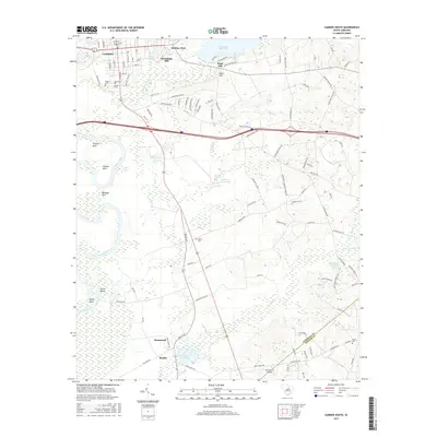
2017 Map of Camden South
USGS Topo · Published 2017About this map
Camden and its southern agricultural hinterlands are defined by the winding course of the Wateree River, which forms a complex series of bends known locally as Friends Neck, Gibsons Neck, and Belmont Neck. This 2017 survey reveals a landscape where historical industry and modern conservation overlap, evidenced by the large Hermitage Mill Pond and Boykin Mill Pond alongside more specialized features like the Retriever Training Pond. The southern portion of the map shows the boundary between Kershaw Co and Sumter Co, near the settlement of Boykin. Genealogists will find significant value in the mapped locations of the Quaker Cem, Jewish Cem, and Boykin Cem, while the inclusion of the Hermitage Mill and El Porvenir Airpark illustrates the varied economic and recreational history of the region.
Find a feature on this map
110 named features on this map. Tap any name to fly to it.
Don’t see what you’re looking for? This feature index may not catch every label — zoom into the map to look around manually.
Map Details
Editions of this 2017 Camden South Map
This is the sole edition of this map. No revisions or reprints were ever made.
Other maps of this area

1935 · Camden
USGS Topo · 1:48,000

1938 · Camden
USGS Topo · 1:62,500

1938 · Hagood
USGS Topo · 1:62,500

1941 · Spartanburg
USGS Topo · 1:250,000

1942 · Camden
USGS Topo · 1:125,000

1953 · Camden South
USGS Topo · 1:24,000

1953 · Lugoff
USGS Topo · 1:24,000

1953 · Rembert
USGS Topo · 1:24,000
1953 · Leesburg
USGS Topo · 1:24,000

1953 · Spartanburg
USGS Topo · 1:250,000