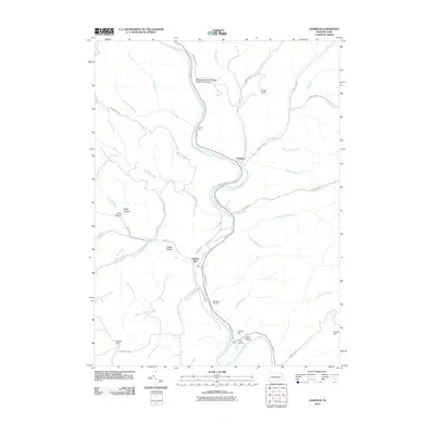
2010 Map of Cameron
USGS Topo · Published 2010About this map
The Driftwood Branch Sinnemahoning Creek carves a winding path through this central Pennsylvania landscape, dictated by the sharp elevations of Tunnel Hill and Grove Hill. The settlement of Cameron sits at a strategic bend in the creek, while the community of Sterling Run is established further south where its namesake waterway meets the main branch. This 2010 topographic record highlights the deeply recessed hollows that define local geography, including May Hollow and Parker Hollow. Genealogy and local history are preserved at sites like Pine Saint Cemetery and Wyle Cemetery, located near the creek banks. Recreational and utility features such as the Wayside Memorial State Forest Picnic Area and Snyder Airport indicate the modern land use within these narrow valleys, which remain dominated by the creek's drainage system and steep ridges like Huston Hill.
Find a feature on this map
50 named features on this map. Tap any name to fly to it.
Don’t see what you’re looking for? This feature index may not catch every label — zoom into the map to look around manually.
Map Details
Editions of this 2010 Cameron Map
This is the sole edition of this map. No revisions or reprints were ever made.
Other maps of this area

1941 · Benezette
USGS Topo · 1:62,500

1943 · Benezette
USGS Topo · 1:62,500

1945 · Driftwood
USGS Topo · 1:48,000

1945 · First Fork
USGS Topo · 1:24,000

1945 · Sinnemahoning
USGS Topo · 1:24,000

1945 · Driftwood
USGS Topo · 1:24,000

1945 · Cameron
USGS Topo · 1:24,000

1947 · Cameron
USGS Topo · 1:24,000

1947 · First Fork
USGS Topo · 1:24,000

1947 · Sinnemahoning
USGS Topo · 1:24,000
Featured Places
- Cameron, Lumber Township
- Gibson Township, PA
- Lumber Township, PA
- Portage Township, PA
- Shippen Township, PA