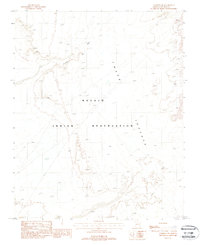
1988 Map of Cameron NE
USGS Topo · Published 1988About this map
Navajo Indian Reservation lands dominate this late-twentieth-century landscape, characterized by the expansive arid formations of the Ward Terrace. The hydrology of the area is defined by the winding course of Fivemile Wash, which cuts through the high desert terrain. Grounded in the mid-1980s via aerial photography and field checks, this survey documents a largely roadless expanse where industrial footprints are limited to an isolated Open Pit Mine and a high-voltage or fuel Pipeline corridor. The presence of migratory Sand Dunes near the wash suggests an active, shifting surface environment, while various 4wd tracks provide the only evidence of modern transit across the terrace.
Find a feature on this map
7 named features on this map. Tap any name to fly to it.
Don’t see what you’re looking for? This feature index may not catch every label — zoom into the map to look around manually.
Map Details
Editions of this 1988 Cameron NE Map
This is the sole edition of this map. No revisions or reprints were ever made.
Other maps of this area

1886 · San Francisco Mtns
USGS Topo · 1:250,000

1886 · Echo Cliffs
USGS Topo · 1:250,000

1891 · San Francisco Mtns
USGS Topo · 1:250,000

1891 · Echo Cliffs
USGS Topo · 1:250,000

1894 · San Francisco Mtns
USGS Topo · 1:250,000

1899 · San Francisco Mtns
USGS Topo · 1:250,000

1947 · Flagstaff
USGS Topo · 1:250,000

1954 · Flagstaff
USGS Topo · 1:250,000

1955 · Cameron SW
USGS Topo · 1:24,000
1955 · Cameron SE
USGS Topo · 1:24,000