1993 Map of Camp Crook
USGS Topo · Published 1996About this map
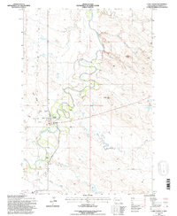
Little Missouri River serpentines through this western South Dakota landscape, shaping the development of Camp Crook and the surrounding ranchlands. The map documents a classic Great Plains ranching economy, centered on the community at Camp Crook where the Municipal Airport and Rodeo Ground sit adjacent to the town center. Long-established cattle operations like the K Bar, Moseley Ranch, and Catron Ranch are anchored to the river's valley, while the higher ground is marked by features like Battle Ridge and Dead Man Hill. Local history and genealogy interests are served by the location of Fairview Cem and the naming of drainage features like Hoag Coal Mine Draw and Grandma Schang Draw, which suggest early land use and family legacies in this corner of Harding County.
Find a feature on this map
24 named features on this map. Tap any name to fly to it.
Don’t see what you’re looking for? This feature index may not catch every label — zoom into the map to look around manually.
Map Details
Editions of this 1993 Camp Crook Map
This is the sole edition of this map. No revisions or reprints were ever made.
Other maps of this area

1935 · Harding
USGS Topo · 1:125,000

1935 · Buffalo
USGS Topo · 1:125,000

1954 · Lemmon
USGS Topo · 1:250,000

1954 · Ekalaka
USGS Topo · 1:250,000

1956 · Ekalaka
USGS Topo · 1:250,000

1957 · Lemmon
USGS Topo · 1:250,000

1958 · Ekalaka
USGS Topo · 1:250,000

1965 · Ekalaka
USGS Topo · 1:250,000
1973 · Gallup Creek
USGS Topo · 1:24,000
1974 · Caroline Butte
USGS Topo · 1:24,000