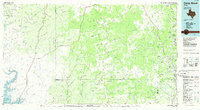
1985 Map of Camp Wood
USGS Topo · Published 1986About this map
The Nueces River and its upper tributaries carve through this mid-1980s landscape of the southwest Texas Hill Country. Settlements like Camp Wood and Barksdale serve as the primary hubs in a region defined by complex drainage systems, including Pulliam Creek and the long Leona Draw. The presence of an Old Railroad Grade stretching north toward Vance offers a glimpse into former transportation corridors that once linked these isolated river valley communities. To the west, the arid terrain transitions toward the Amistad Reservoir and the Amistad National Recreation Area, where the West Fork San Pedro Creek meets the water's edge. Throughout the quadrangle, numerous family-named landmarks and water sources, such as Boiling Mtn Spring and Palace Cave, reflect the importance of groundwater in this semi-arid environment, while scattered landing strips and the County Airport highlight the modern reliance on light aircraft for traversing the expansive county boundaries.
Find a feature on this map
112 named features on this map. Tap any name to fly to it.
Don’t see what you’re looking for? This feature index may not catch every label — zoom into the map to look around manually.
Map Details
Editions of this 1985 Camp Wood Map
2 editions found
Other maps of this area

1893 · Rock Springs
USGS Topo · 1:125,000

1893 · Nueces
USGS Topo · 1:125,000

1896 · Nueces
USGS Topo · 1:125,000

1896 · Brackett
USGS Topo · 1:125,000

1897 · Brackett
USGS Topo · 1:125,000

1898 · Uvalde
USGS Topo · 1:125,000

1899 · Uvalde
USGS Topo · 1:125,000

1938 · Turkey Mountain
USGS Topo · 1:48,000

1941 · Standart
USGS Topo · 1:62,500

1941 · Feely
USGS Topo · 1:62,500