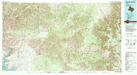
1985 Map of Camp Wood
USGS Topo · Published 1994About this map
The Nueces River and West Nueces River systems define this 1980s landscape at the transition from the Edwards Plateau toward the Rio Grande basin. The eastern portion of the map is anchored by the community of Camp Wood and the nearby settlement of Barksdale, where the river valley creates a pocket of habitation amidst high bluffs like Rainbow Bluff. To the west, the arid drainage patterns of the Dry Devils River and Dolan Creek dominate a more sparsely populated expanse, eventually feeding into the Amistad Reservoir at the southwestern corner.
Find a feature on this map
42 named features on this map. Tap any name to fly to it.
Don’t see what you’re looking for? This feature index may not catch every label — zoom into the map to look around manually.
Map Details
Editions of this 1985 Camp Wood Map
2 editions found
Other maps of this area

1893 · Rock Springs
USGS Topo · 1:125,000

1893 · Nueces
USGS Topo · 1:125,000

1896 · Nueces
USGS Topo · 1:125,000

1896 · Brackett
USGS Topo · 1:125,000

1897 · Brackett
USGS Topo · 1:125,000

1898 · Uvalde
USGS Topo · 1:125,000

1899 · Uvalde
USGS Topo · 1:125,000

1938 · Turkey Mountain
USGS Topo · 1:48,000

1941 · Standart
USGS Topo · 1:62,500

1941 · Feely
USGS Topo · 1:62,500