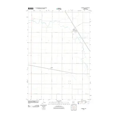
2010 Map of Campbell
USGS Topo · Published 2010About this map
Campbell occupies the northeast corner of this Wilkin County landscape, situated at the junction of County Hwy-17 and the diagonal path of Route 9. The town center includes the Campbell Post Office, serving as a focal point for the surrounding agricultural grid. The meandering Rabbit River and its South Fork Rabbit River carve winding paths across the otherwise strictly rectilinear township and range system. To the southwest, the small settlement of Tenney sits at the intersection of County Hwy-13 and Highway 55. This map captures a landscape defined by its rural road network, with numbered township roads like Twp Hwy 120 and Twp Hwy 145 M providing access to the vast acreage between these two prairie communities.
Find a feature on this map
37 named features on this map. Tap any name to fly to it.
Don’t see what you’re looking for? This feature index may not catch every label — zoom into the map to look around manually.
Map Details
Editions of this 2010 Campbell Map
This is the sole edition of this map. No revisions or reprints were ever made.
Other maps of this area

1904 · Wahpeton
USGS Topo · 1:125,000

1915 · White Rock
USGS Topo · 1:62,500

1918 · White Rock
USGS Topo · 1:62,500

1951 · Wheaton
USGS Topo · 1:62,500

1951 · Campbell
USGS Topo · 1:62,500

1953 · Milbank
USGS Topo · 1:250,000

1953 · Fargo
USGS Topo · 1:250,000

1956 · Fargo
USGS Topo · 1:250,000

1958 · Milbank
USGS Topo · 1:250,000
1972 · Boisberg
USGS Topo · 1:24,000