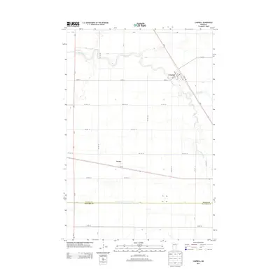
2013 Map of Campbell
USGS Topo · Published 2013About this map
Agricultural lands of the Red River Valley define this area where the Rabbit River and the S Fork Rabbit River meander through a highly engineered drainage landscape. The village of Campbell serves as the primary hub, where local navigation relies on the intersection of MN-9, Us-75, and a grid of streets including Pacific Ave and Atlantic Ave. A Po marks the center of town life near the rail corridor that parallels the highway. South of Campbell, the small settlement of Tenney sits along the southern edge of the county. The transition between Wilkin Co and Traverse County is marked by the straight line of Judicial Ditch Number Eleven-Seven, a massive drainage project that reflects the region's intensive water management for farming. A vast network of township roads, such as Twp Hwy 116 and Twp Hwy 120, provides access to the surrounding farmsteads.
Find a feature on this map
34 named features on this map. Tap any name to fly to it.
Don’t see what you’re looking for? This feature index may not catch every label — zoom into the map to look around manually.
Map Details
Editions of this 2013 Campbell Map
This is the sole edition of this map. No revisions or reprints were ever made.
Other maps of this area

1904 · Wahpeton
USGS Topo · 1:125,000

1915 · White Rock
USGS Topo · 1:62,500

1918 · White Rock
USGS Topo · 1:62,500

1951 · Wheaton
USGS Topo · 1:62,500

1951 · Campbell
USGS Topo · 1:62,500

1953 · Milbank
USGS Topo · 1:250,000

1953 · Fargo
USGS Topo · 1:250,000

1956 · Fargo
USGS Topo · 1:250,000

1958 · Milbank
USGS Topo · 1:250,000
1972 · Boisberg
USGS Topo · 1:24,000