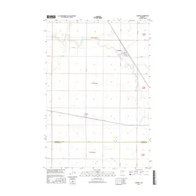
2016 Map of Campbell
USGS Topo · Published 2016About this map
The town of Campbell and the small village of Tenney sit within a highly organized agricultural landscape in the Red River Valley region of western Minnesota. This survey highlights the meandering path of the Rabbit River and its S Fork Rabbit River, which provides the primary drainage through the flat plains of the Wilkin County and Traverse County border region. A rigid grid of section lines and county roads, such as Co Hwy 4 and Co Hwy 13, defines the property boundaries and transport routes of this prairie farming district. In the town of Campbell, the street plan features distinctively named thoroughfares like Connecticut Ave and New York Ave, oriented toward the rail-aligned town center. The map's detail provides a clear look at the rural intersection of hydrology and human settlement in the northern grain belt.
Find a feature on this map
33 named features on this map. Tap any name to fly to it.
Don’t see what you’re looking for? This feature index may not catch every label — zoom into the map to look around manually.
Map Details
Editions of this 2016 Campbell Map
This is the sole edition of this map. No revisions or reprints were ever made.
Other maps of this area

1904 · Wahpeton
USGS Topo · 1:125,000

1915 · White Rock
USGS Topo · 1:62,500

1918 · White Rock
USGS Topo · 1:62,500

1951 · Wheaton
USGS Topo · 1:62,500

1951 · Campbell
USGS Topo · 1:62,500

1953 · Milbank
USGS Topo · 1:250,000

1953 · Fargo
USGS Topo · 1:250,000

1956 · Fargo
USGS Topo · 1:250,000

1958 · Milbank
USGS Topo · 1:250,000
1972 · Boisberg
USGS Topo · 1:24,000