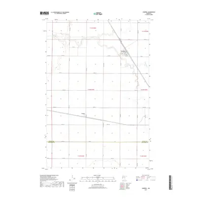
2019 Map of Campbell
USGS Topo · Published 2019About this map
The Rabbit River meanders across the northern plains of this agricultural landscape, defining the northern geography of the Wilkin Co and Traverse Co borderlands. The village of Campbell stands as the primary hub in the northeast, where the local street grid is anchored by Atlantic Ave and Pacific Ave, names reflecting the heavy rail influence on prairie settlement. Further south, the small community of Tenney marks a junction point near the southern reaches of the township lines. The terrain is notably flat, dominated by the drainage patterns of the river and its southern branch, the S Fork Rabbit River. This survey illustrates the rigid section-line road network that facilitates large-scale farming in the Red River Valley region, showing how the rural infrastructure connects these isolated outposts.
Find a feature on this map
56 named features on this map. Tap any name to fly to it.
Don’t see what you’re looking for? This feature index may not catch every label — zoom into the map to look around manually.
Map Details
Editions of this 2019 Campbell Map
This is the sole edition of this map. No revisions or reprints were ever made.
Other maps of this area

1904 · Wahpeton
USGS Topo · 1:125,000

1915 · White Rock
USGS Topo · 1:62,500

1918 · White Rock
USGS Topo · 1:62,500

1951 · Wheaton
USGS Topo · 1:62,500

1951 · Campbell
USGS Topo · 1:62,500

1953 · Milbank
USGS Topo · 1:250,000

1953 · Fargo
USGS Topo · 1:250,000

1956 · Fargo
USGS Topo · 1:250,000

1958 · Milbank
USGS Topo · 1:250,000
1972 · Boisberg
USGS Topo · 1:24,000