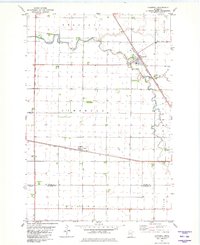
1981 Map of Campbell
USGS Topo · Published 1981About this map
Campbell serves as a focal point for this Red River Valley agricultural landscape in the early 1980s, situated at the junction of the Burlington Northern and Soo Line railroads. The town’s layout is closely tied to these corridors, with a Cem and Sew Disp Ponds located just to the south along the banks of the winding Rabbit River. The surrounding prairie is defined by an extensive drainage network, including Judicial Ditch No 11 and several others that crisscross the townships of Brandrup, Bradford, and Campbell. To the south, the village of Tenney sits along the Soo Line tracks near a prominent Radio Tower. The landscape transitions at the Wilkin Co Traverse Co line, where the headwaters of the South Fork Mustinka River begin their meandering course through the township of Tintah.
Find a feature on this map
21 named features on this map. Tap any name to fly to it.
Don’t see what you’re looking for? This feature index may not catch every label — zoom into the map to look around manually.
Map Details
Editions of this 1981 Campbell Map
This is the sole edition of this map. No revisions or reprints were ever made.
Other maps of this area

1904 · Wahpeton
USGS Topo · 1:125,000

1915 · White Rock
USGS Topo · 1:62,500

1918 · White Rock
USGS Topo · 1:62,500

1951 · Wheaton
USGS Topo · 1:62,500

1951 · Campbell
USGS Topo · 1:62,500

1953 · Milbank
USGS Topo · 1:250,000

1953 · Fargo
USGS Topo · 1:250,000

1956 · Fargo
USGS Topo · 1:250,000

1958 · Milbank
USGS Topo · 1:250,000
1972 · Boisberg
USGS Topo · 1:24,000