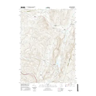
2016 Map of Canaan
USGS Topo · Published 2016About this map
The Taconic Range defines the eastern edge of this Columbia County landscape, where the New York and Massachusetts border runs along the high ridges of Perry Peak. This region is characterized by a network of hamlets connected by the winding Wyomanock Cr and the Columbia Pike. Settlements such as Lebanon Springs and New Lebanon Center serve as historical anchors in the north, while the southern portion of the map is dominated by Queechy Lake and the village of Canaan. The mapping of several family and community burial grounds, including the Mott Cem, Cem of the Evergreens, and the Cornwall-Tilden Cem, provides significant value for genealogical research. The presence of Shaker Swamp and Canaan Shaker Rd indicates the local heritage of Shaker communities that once thrived in this valley. Waterways like Kinderhook Creek and Flat Brook drain the complex terrain, which includes landmarks such as The Knob and the curiously named Rattlesnake Den.
Find a feature on this map
107 named features on this map. Tap any name to fly to it.
Don’t see what you’re looking for? This feature index may not catch every label — zoom into the map to look around manually.
Map Details
Editions of this 2016 Canaan Map
This is the sole edition of this map. No revisions or reprints were ever made.
Other maps of this area

1888 · Berlin
USGS Topo · 1:62,500

1888 · Pittsfield
USGS Topo · 1:62,500

1890 · Pittsfield
USGS Topo · 1:62,500

1890 · Berlin
USGS Topo · 1:62,500

1893 · Troy
USGS Topo · 1:62,500

1893 · Pittsfield
USGS Topo · 1:62,500

1894 · Berlin
USGS Topo · 1:62,500

1894 · Pittsfield
USGS Topo · 1:62,500

1895 · Troy
USGS Topo · 1:62,500

1897 · Pittsfield
USGS Topo · 1:62,500