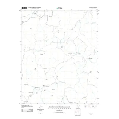
2011 Map of Canaan
USGS Topo · Published 2011About this map
Canaan sits at the center of a complex network of hollows and ridges in this northern Arkansas landscape, where the Middle Fork Little Red River and its numerous tributaries like Little Red Creek and Crooked Branch carve through the terrain. The map reveals a pattern of dispersed upland settlement, with small communities like Watts, Kay, and Booster connected by a web of county roads. Higher elevations are marked by prominent summits, including Bohannon Mountain and Star Mountain, while family names are preserved through landmarks such as Barnes Hollow, Nolan Point, and Dean Mountain. For genealogists, the inclusion of Oak Hill Cemetery and Thompson Cemetery provides specific points of interest for tracing local family lineages. The distribution of these features reflects a rural economy shaped by the winding creek beds and the high knobs of the region during the early 21st century.
Find a feature on this map
65 named features on this map. Tap any name to fly to it.
Don’t see what you’re looking for? This feature index may not catch every label — zoom into the map to look around manually.
Map Details
Editions of this 2011 Canaan Map
This is the sole edition of this map. No revisions or reprints were ever made.
Other maps of this area

1879 · Washington
USGS Topo · 1:62,500

1887 · Smyrna
USGS Topo · 1:62,500

1889 · Marshall #3
USGS Topo · 1:62,500

1892 · Marshall
USGS Topo · 1:125,000

1894 · Marshall
USGS Topo · 1:125,000

1901 · Marshall
USGS Topo · 1:125,000

1939 · Snowball
USGS Topo · 1:62,500

1940 · Smyrna
USGS Topo · 1:62,500

1941 · Snowball
USGS Topo · 1:62,500

1942 · Snowball
USGS Topo · 1:62,500