
1901 Map of Marshall
USGS Topo · Published 1901About this map
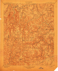
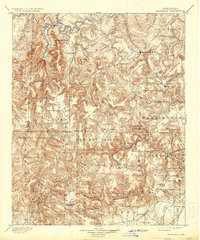
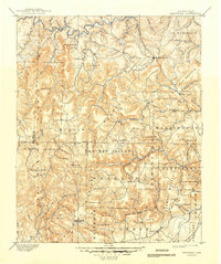
Marshall stands as a central point in this late nineteenth-century survey of the Arkansas highlands, where the Boston Mountain range creates a complex landscape of ridges and deep hollows. The drainage patterns of the Buffalo Fork White River in the north and the South Fork Little Red River in the south dictate the placement of early settlements like Wolems and Snowball. The map captures a transition in land use, showing the emerging Archey Valley and the distinct peaks of Wheeler Mountain and Crowell Mountain. Cultural landmarks and early transportation routes are evident in labels such as the Payton Trail and scattered rural hubs like Witts Springs and Scotland. The intricate contour work reveals the isolated nature of high-elevation points like Point Peter and Lost Mt, highlighting the challenging terrain that early settlers negotiated before the turn of the century.
Find a feature on this map
84 named features on this map. Tap any name to fly to it.
Don’t see what you’re looking for? This feature index may not catch every label — zoom into the map to look around manually.
Map Details
Editions of this 1901 Marshall Map
4 editions found
Other maps of this area

1879 · Washington
USGS Topo · 1:62,500

1887 · Smyrna
USGS Topo · 1:62,500

1888 · Dardanelle #1
USGS Topo · 1:62,500

1889 · Treat
USGS Topo · 1:62,500

1889 · Marshall #3
USGS Topo · 1:62,500

1890 · Dardanelle
USGS Topo · 1:125,000

1890 · Mountain Home
USGS Topo · 1:125,000

1891 · Mountain Home
USGS Topo · 1:125,000

1892 · Marshall
USGS Topo · 1:125,000

1892 · Mountain View
USGS Topo · 1:125,000