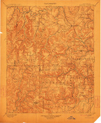
1901 Map of Marshall
USGS Topo · Published 1912About this map
Marshall stands as the primary hub in this early 20th-century survey of the Ozark plateau, situated amidst a landscape defined by the drainage systems of the Buffalo River to the north and the Middle Fork Little Red River to the south. The terrain is marked by significant peaks such as Blue Mountain and Clinton Mountain, while the township of Archey Valley and the forested expanse of The Wilderness illustrate the varied rural character of Searcy and Van Buren counties.
Find a feature on this map
96 named features on this map. Tap any name to fly to it.
Don’t see what you’re looking for? This feature index may not catch every label — zoom into the map to look around manually.
Map Details
Editions of this 1901 Marshall Map
4 editions found

Other maps of this area

1879 · Washington
USGS Topo · 1:62,500

1887 · Smyrna
USGS Topo · 1:62,500

1888 · Dardanelle #1
USGS Topo · 1:62,500

1889 · Treat
USGS Topo · 1:62,500

1889 · Marshall #3
USGS Topo · 1:62,500

1890 · Dardanelle
USGS Topo · 1:125,000

1890 · Mountain Home
USGS Topo · 1:125,000

1891 · Mountain Home
USGS Topo · 1:125,000

1892 · Marshall
USGS Topo · 1:125,000

1892 · Mountain View
USGS Topo · 1:125,000