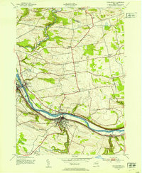
1944 Map of Canajoharie
USGS Topo · Published 1953About this map
The Mohawk River corridor serves as the industrial and transit spine of this landscape, where the Barge Canal and the New York Central railroad run parallel through the valley. The twin settlements of Canajoharie and Palatine Bridge anchor the center of the sheet, connected by bridges over the water. Away from the river, the terrain rises into the rolling hills of Palatine and Canajoharie townships, marked by a network of rural schools like School No 4 and School No 6. Historic hamlets such as Stone Arabia and Ephratah are detailed alongside family landmarks like the Dillenback Cem and Sitterly Cem. The presence of an Airway Beacon near Cook Corners reflects the mid-century modernization of navigation, while the steep descent of Canajoharie Creek at Canajoharie Falls highlights the area's natural drainage patterns.
Find a feature on this map
49 named features on this map. Tap any name to fly to it.
Don’t see what you’re looking for? This feature index may not catch every label — zoom into the map to look around manually.
Map Details
Editions of this 1944 Canajoharie Map
2 editions found
Other maps of this area

1896 · Fonda
USGS Topo · 1:62,500

1898 · Fonda
USGS Topo · 1:62,500

1898 · Canajoharie
USGS Topo · 1:62,500

1900 · Canajoharie
USGS Topo · 1:62,500

1901 · Lassellsville
USGS Topo · 1:62,500

1902 · Canajoharie
USGS Topo · 1:62,500

1902 · Fonda
USGS Topo · 1:62,500

1903 · Gloversville
USGS Topo · 1:62,500

1903 · Lassellsville
USGS Topo · 1:62,500

1943 · Gloversville
USGS Topo · 1:62,500