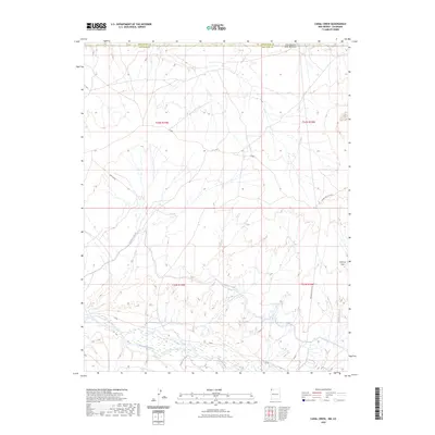
2023 Map of Canal Creek
USGS Topo · Published 2023About this map
The San Juan River flows across the southern portion of this landscape, defining the hydrology and land use near the border between New Mexico and Colorado. This arid region in San Juan County is characterized by a network of drainage systems and man-made water management features, most notably the Hogback Canal, which snakes through the central and southern terrain. The high point of Volcano Peak stands in the southeast, overlooking the confluence of natural seasonal waterways like Shiprock Wash and Malpais Arroyo. Transportation in the area relies on specialized infrastructure including Pipe Line Rd and Indian Svc Rte 5030, reflecting the region's focus on utility corridors and service access. The map captures the intersection of traditional natural features and the engineered irrigation and road networks that support life along the river valley.
Find a feature on this map
16 named features on this map. Tap any name to fly to it.
Don’t see what you’re looking for? This feature index may not catch every label — zoom into the map to look around manually.
Map Details
Editions of this 2023 Canal Creek Map
This is the sole edition of this map. No revisions or reprints were ever made.
Other maps of this area

1889 · Chaco
USGS Topo · 1:250,000

1892 · Chaco
USGS Topo · 1:250,000

1934 · Chimney Rock
USGS Topo · 1:62,500

1934 · Rattlesnake
USGS Topo · 1:62,500

1936 · Chimney Rock
USGS Topo · 1:62,500

1937 · Rattlesnake
USGS Topo · 1:62,500

1954 · Shiprock
USGS Topo · 1:250,000

1956 · Cortez
USGS Topo · 1:250,000

1958 · Cortez
USGS Topo · 1:250,000

1958 · Shiprock
USGS Topo · 1:250,000