
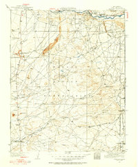
1934 Map of Rattlesnake
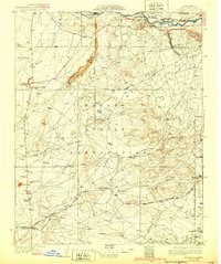
USGS Topo · Published 1971About this map
The San Juan River defines the heart of this landscape, carving a wide path through the Navajo Indian Reservation during the early 1930s. This survey records a transition point where the river meets several significant drainage systems, including Tohache Wash, Red Wash, and Shiprock Wash. The geography is centered around the unique intersection at Four Corners, where the boundaries of New Mexico, Colorado, and Arizona converge. Small settlements like Cudai and Rattlesnake represent the sparse human footprint in this arid region, while the Mancos River flows in from the north. The map details a network of unimproved dirt roads and light-duty paths that connected these isolated outposts before the development of modern highway infrastructure, providing a clear view of the territorial borders and the natural terrain at Bitlabito.
Find a feature on this map
16 named features on this map. Tap any name to fly to it.
Don’t see what you’re looking for? This feature index may not catch every label — zoom into the map to look around manually.
Map Details
Editions of this 1934 Rattlesnake Map
This is the sole edition of this map. No revisions or reprints were ever made.
Other maps of this area

1886 · Abajo
USGS Topo · 1:250,000

1889 · Chaco
USGS Topo · 1:250,000

1892 · Abajo
USGS Topo · 1:250,000

1892 · Chaco
USGS Topo · 1:250,000

1892 · Canyon De Chelly
USGS Topo · 1:250,000

1893 · Abajo
USGS Topo · 1:250,000

1927 · Sulphur Spring
USGS Topo · 1:96,000
1928 · Kirtland
USGS Topo · 1:125,000
1932 · Kirtland
USGS Topo · 1:125,000
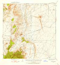
1934 · Ship Rock
USGS Topo · 1:62,500
Featured Places
- Shiprock Agency
- Gadii'ahi, Shiprock Agency
- Rattlesnake, Shiprock Agency
- San Juan County, NM
- Montezuma County, CO