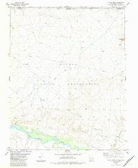
1983 Map of Canal Creek
USGS Topo · Published 1984About this map
The San Juan River defines the southern boundary of this high-desert landscape along the border of New Mexico and Colorado. As of the early 1980s, the terrain is characterized by a sophisticated network of water management features designed to navigate the arid environment of the Navajo Indian Reservation and Ute Mountain Indian Reservation. The Hogback Canal cuts across the plains, supported by infrastructure such as a Siphon and an Aqueduct to move water toward agricultural or industrial needs.
Find a feature on this map
15 named features on this map. Tap any name to fly to it.
Don’t see what you’re looking for? This feature index may not catch every label — zoom into the map to look around manually.
Map Details
Editions of this 1983 Canal Creek Map
This is the sole edition of this map. No revisions or reprints were ever made.
Other maps of this area

1889 · Chaco
USGS Topo · 1:250,000

1892 · Chaco
USGS Topo · 1:250,000

1934 · Chimney Rock
USGS Topo · 1:62,500

1934 · Rattlesnake
USGS Topo · 1:62,500

1936 · Chimney Rock
USGS Topo · 1:62,500

1937 · Rattlesnake
USGS Topo · 1:62,500

1954 · Shiprock
USGS Topo · 1:250,000

1956 · Cortez
USGS Topo · 1:250,000

1958 · Cortez
USGS Topo · 1:250,000

1958 · Shiprock
USGS Topo · 1:250,000