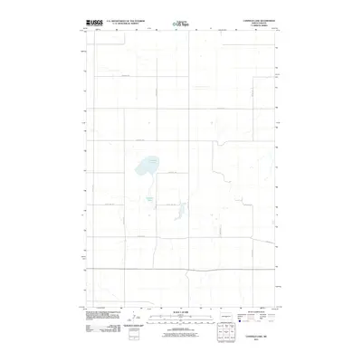
2011 Map of Canfield Lake
USGS Topo · Published 2011About this map
Canfield Lake serves as the central focal point of this North Dakota prairie landscape, surrounded by a precise grid of section-line roads that define the region's agricultural layout. In the southern portion of the quadrangle, Old Hwy 36 cuts an east-west path through the countryside, reflecting the area's early transportation infrastructure. The map illustrates a series of smaller water bodies and wetlands connected to the primary lake, showing how local drainage patterns interact with the established rural road network. This grid, including corridors like 210th St Ne and 383rd Ave Ne, segments the land into the traditional township and range squares common across the Great Plains, providing a clear view of the rural spatial organization in Burleigh County during the early 21st century.
Find a feature on this map
14 named features on this map. Tap any name to fly to it.
Don’t see what you’re looking for? This feature index may not catch every label — zoom into the map to look around manually.
Map Details
Editions of this 2011 Canfield Lake Map
This is the sole edition of this map. No revisions or reprints were ever made.
Other maps of this area

1954 · McClusky
USGS Topo · 1:250,000

1958 · McClusky
USGS Topo · 1:250,000

1959 · Mercer SE
USGS Topo · 1:24,000

1960 · Horse Lake
USGS Topo · 1:24,000

1960 · Florence Lake
USGS Topo · 1:24,000

1975 · Wing SE
USGS Topo · 1:24,000
1975 · Wing SW
USGS Topo · 1:24,000
1975 · Regan SE
USGS Topo · 1:24,000
1979 · Regan
USGS Topo · 1:24,000

1979 · Canfield Lake
USGS Topo · 1:24,000