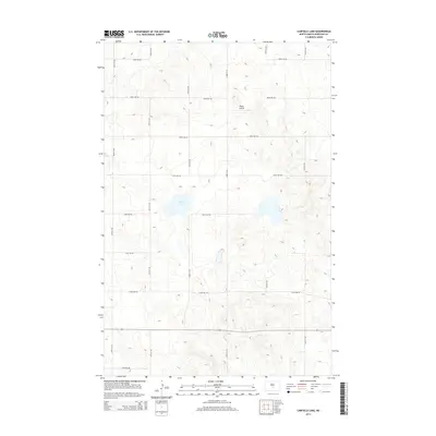
2014 Map of Canfield Lake
USGS Topo · Published 2014About this map
Canfield Lake sits as the central geographic feature of this Burleigh County landscape, surrounded by a regularized grid of rural section-line roads. The terrain is characterized by prairie potholes and wetlands typical of the Northern Plains, organized by a network of local routes such as 370th Ave Ne and 210th St Ne. In the northeastern quadrant, the Regan Airstrip provides a rare point of built infrastructure in an area otherwise dominated by agriculture and natural depressions. This 2014 survey by the U.S. Geological Survey reflects the enduring surveyor's grid of the American West, where even modern roads like 396th Ave Ne follow the rigid cardinal lines established over a century prior. The lack of concentrated town sites emphasizes the low-density, open-field nature of this part of North Dakota.
Find a feature on this map
16 named features on this map. Tap any name to fly to it.
Don’t see what you’re looking for? This feature index may not catch every label — zoom into the map to look around manually.
Map Details
Editions of this 2014 Canfield Lake Map
This is the sole edition of this map. No revisions or reprints were ever made.
Other maps of this area

1954 · McClusky
USGS Topo · 1:250,000

1958 · McClusky
USGS Topo · 1:250,000

1959 · Mercer SE
USGS Topo · 1:24,000

1960 · Horse Lake
USGS Topo · 1:24,000

1960 · Florence Lake
USGS Topo · 1:24,000

1975 · Wing SE
USGS Topo · 1:24,000
1975 · Wing SW
USGS Topo · 1:24,000
1975 · Regan SE
USGS Topo · 1:24,000
1979 · Regan
USGS Topo · 1:24,000

1979 · Canfield Lake
USGS Topo · 1:24,000