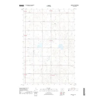
2018 Map of Canfield Lake
USGS Topo · Published 2018About this map
Canfield Lake sits at the center of this rural landscape in northern Burleigh County, where the topography is defined by numerous small depressions and wetland basins. The area’s cultural history is quietly marked by the Jewish Cem located near the intersection of 344th Ave NE and 197th St NE, a significant landmark for genealogists and local historians documenting early settlement patterns. Aviation and transit are represented by the Regan Airstrip to the north and the path of Old Hwy 36 crossing the southern half of the sheet. The map illustrates a strictly organized section-line road grid, including 396th Ave NE and 223rd St NE, which facilitates access to the surrounding agricultural tracts and the scattered water bodies that characterize this portion of the North Dakota plains.
Find a feature on this map
24 named features on this map. Tap any name to fly to it.
Don’t see what you’re looking for? This feature index may not catch every label — zoom into the map to look around manually.
Map Details
Editions of this 2018 Canfield Lake Map
This is the sole edition of this map. No revisions or reprints were ever made.
Other maps of this area

1954 · McClusky
USGS Topo · 1:250,000

1958 · McClusky
USGS Topo · 1:250,000

1959 · Mercer SE
USGS Topo · 1:24,000

1960 · Horse Lake
USGS Topo · 1:24,000

1960 · Florence Lake
USGS Topo · 1:24,000

1975 · Wing SE
USGS Topo · 1:24,000
1975 · Wing SW
USGS Topo · 1:24,000
1975 · Regan SE
USGS Topo · 1:24,000
1979 · Regan
USGS Topo · 1:24,000

1979 · Canfield Lake
USGS Topo · 1:24,000