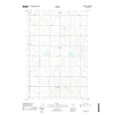
2020 Map of Canfield Lake
USGS Topo · Published 2020About this map
Jewish Cem, a small burial ground located west of the 197th Street NE corridor, stands as a notable cultural landmark within this landscape of rolling prairie and seasonal wetlands. The terrain is centered on the waters of Canfield Lake, where the surrounding topography is marked by a high density of small depressions and potholes characteristic of the Missouri Coteau region. Aviation infrastructure is represented by the Regan Airstrip to the north, while the local transportation network is defined by a strict section-line grid of rural roads, including 396th Ave NE and 305th Ave NE. The presence of Old Hwy 36 traversing the southern portion of the sheet provides evidence of earlier transit corridors through Burleigh County, connecting these remote agricultural sections to the wider state network.
Find a feature on this map
24 named features on this map. Tap any name to fly to it.
Don’t see what you’re looking for? This feature index may not catch every label — zoom into the map to look around manually.
Map Details
Editions of this 2020 Canfield Lake Map
This is the sole edition of this map. No revisions or reprints were ever made.
Other maps of this area

1954 · McClusky
USGS Topo · 1:250,000

1958 · McClusky
USGS Topo · 1:250,000

1959 · Mercer SE
USGS Topo · 1:24,000

1960 · Horse Lake
USGS Topo · 1:24,000

1960 · Florence Lake
USGS Topo · 1:24,000

1975 · Wing SE
USGS Topo · 1:24,000
1975 · Wing SW
USGS Topo · 1:24,000
1975 · Regan SE
USGS Topo · 1:24,000
1979 · Regan
USGS Topo · 1:24,000

1979 · Canfield Lake
USGS Topo · 1:24,000