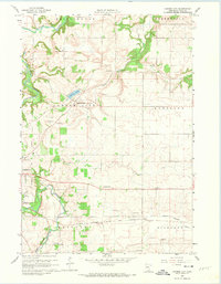
1960 Map of Cannon City
USGS Topo · Published 1974About this map
The Cannon River and Straight River converge at the western edge of this 1960 landscape, where the Faribault City Boundary encloses the grounds of the State Hospital and several large limestone Quarries. This portion of Rice County reveals a mid-century rural infrastructure centered on established townships like Cannon City, Wheeling, and Richland. The economic life of the area is visible in the numerous Gravel Pits dotting the prairie and the passage of two major rail lines: the Chicago Milwaukee St Paul and Pacific and the Chicago Rock Island and Pacific. Small communities and vanished rural social hubs are documented through the presence of Prairieville, Ruskin, and several local landmarks including the Wide Awake Sch and School No 1173. Drainage patterns of the Prairie Creek and the headwaters of the North Branch Zumbro River illustrate the transition from river valley to open upland.
Find a feature on this map
28 named features on this map. Tap any name to fly to it.
Don’t see what you’re looking for? This feature index may not catch every label — zoom into the map to look around manually.
Map Details
Editions of this 1960 Cannon City Map
2 editions found
Other maps of this area

1953 · Saint Paul
USGS Topo · 1:250,000

1959 · Saint Paul
USGS Topo · 1:250,000

1960 · Faribault
USGS Topo · 1:24,000

1960 · Northfield
USGS Topo · 1:24,000

1960 · Cannon City
USGS Topo · 1:24,000

1960 · Dennison
USGS Topo · 1:24,000

1960 · Little Chicago
USGS Topo · 1:24,000

1960 · Nerstrand
USGS Topo · 1:24,000

1962 · Medford East
USGS Topo · 1:24,000

1962 · Moland
USGS Topo · 1:24,000