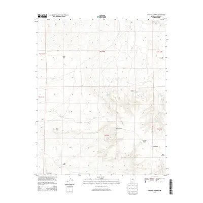
2013 Map of Cantaralo Spring
USGS Topo · Published 2013About this map
Cantaralo Spring and the surrounding high desert terrain define this corner of Cibola County, where water sources are the primary landmarks for ranching and navigation. The 2013 landscape is punctuated by essential water infrastructure, including the Cantaralo Windmill and the evocatively named Hinkson High Lonesome Windmill. Human presence is sparse but distinct at Mazon Camp, while the topography is dominated by the massive Zuñi Plateau and the deep incisions of Blanco Canyon and Duran Canyon. Numerous cattle tanks and draws, such as Dead Forest Tank and Aguaje Draw, indicate the seasonal movement of water through this arid environment. The map details a network of 4WD trails and primitive roads that connect these remote outposts, reflecting the enduring cattle-rearing economy of the region.
Find a feature on this map
23 named features on this map. Tap any name to fly to it.
Don’t see what you’re looking for? This feature index may not catch every label — zoom into the map to look around manually.
Map Details
Editions of this 2013 Cantaralo Spring Map
This is the sole edition of this map. No revisions or reprints were ever made.
Other maps of this area

1886 · St Johns
USGS Topo · 1:250,000

1892 · St Johns
USGS Topo · 1:250,000

1954 · Saint Johns
USGS Topo · 1:250,000

1957 · Saint Johns
USGS Topo · 1:250,000

1958 · Saint Johns
USGS Topo · 1:250,000

1962 · Saint Johns
USGS Topo · 1:250,000

1972 · Twentytwo Spring
USGS Topo · 1:24,000

1972 · Cantaralo Spring
USGS Topo · 1:24,000
1972 · Atarque Lake
USGS Topo · 1:24,000
1972 · Moreno Hill
USGS Topo · 1:24,000