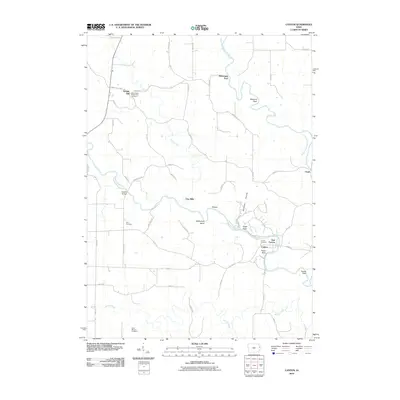
2010 Map of Canton
USGS Topo · Published 2010About this map
Temple Hill anchors the northwestern corner of this landscape, situated along the rolling terrain where local road networks converge. A central point for family history and local heritage is the Saint Peters Temple Hill Cemetery, which serves as a long-standing marker of the area's rural settlement patterns. The map highlights a quiet, pastoral region defined primarily by its dispersed homesteads and the winding paths of Form Creek. The scarcity of dense commercial development at this time reflects a community deeply tied to the land and traditional agricultural life, providing a clear record of the local geography before more modern shifts in rural infrastructure.
Find a feature on this map
2 named features on this map. Tap any name to fly to it.
Don’t see what you’re looking for? This feature index may not catch every label — zoom into the map to look around manually.
Map Details
Editions of this 2010 Canton Map
This is the sole edition of this map. No revisions or reprints were ever made.
Other maps of this area

1891 · Monticello
USGS Topo · 1:62,500

1891 · Baldwin
USGS Topo · 1:62,500

1900 · Anamosa
USGS Topo · 1:125,000

1901 · Peosta
USGS Topo · 1:125,000

1959 · Dubuque
USGS Topo · 1:250,000

1961 · Dubuque
USGS Topo · 1:250,000

1962 · Dubuque
USGS Topo · 1:250,000
1966 · Bernard
USGS Topo · 1:24,000
1966 · Fillmore
USGS Topo · 1:24,000
1966 · Cascade
USGS Topo · 1:24,000