1925 Map of Cape May
USGS Topo · Published 1925About this map
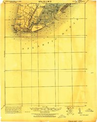
Cape May City and the surrounding coastal landscape are depicted here following revisions from the early 20th century. The map illustrates a developed shorefront with distinct settlements like Wildwood, Anglesea, and North Wildwood connected by a network of railroads, including the Atlantic City R.R. and the West Jersey & Seashore R.R. infrastructure. Maritime safety is a prominent theme, evidenced by numerous Life Saving Stations such as L.S. Station Turtle Gut and the iconic Cape May Light at the peninsula's tip.
Find a feature on this map
34 named features on this map. Tap any name to fly to it.
Don’t see what you’re looking for? This feature index may not catch every label — zoom into the map to look around manually.
Map Details
Editions of this 1925 Cape May Map
This is the sole edition of this map. No revisions or reprints were ever made.
Other maps of this area

1884 · Sea Isle
USGS Topo · 1:62,500

1888 · Cape May
USGS Topo · 1:62,500

1888 · Dennisville
USGS Topo · 1:62,500

1888 · Sea Isle
USGS Topo · 1:62,500

1890 · Maurice Cove
USGS Topo · 1:62,500

1891 · Maurice Cove
USGS Topo · 1:62,500

1893 · Cape May
USGS Topo · 1:62,500

1894 · Dennisville
USGS Topo · 1:62,500

1894 · Sea Isle
USGS Topo · 1:62,500

1898 · Cape May
USGS Topo · 1:62,500