1981 Map of Cape May
USGS Topo · Published 1982About this map
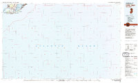
Cape May and the surrounding coastal communities of Cape May County appear here during the early 1980s, revealing a landscape defined by its maritime heritage and military presence. The southern tip of the peninsula is anchored by the U.S. Coast Guard Training Center and U.S. Coast Guard Reservation, emphasizing the area's strategic importance at the mouth of the Delaware Bay. The map highlights the intricate network of tidal waterways, including Jarvis Sound and Cape Island Creek, which separate the residential clusters of West Cape May and Cold Spring from the Atlantic shoreline. Inland settlements like Erma and Bennett provide a look at the mainland development patterns adjacent to protected natural spaces like Cape May Point State Park and the Marmora Wildlife Management Area.
Find a feature on this map
22 named features on this map. Tap any name to fly to it.
Don’t see what you’re looking for? This feature index may not catch every label — zoom into the map to look around manually.
Map Details
Editions of this 1981 Cape May Map
This is the sole edition of this map. No revisions or reprints were ever made.
Other maps of this area

1884 · Sea Isle
USGS Topo · 1:62,500

1888 · Cape May
USGS Topo · 1:62,500

1888 · Dennisville
USGS Topo · 1:62,500

1888 · Sea Isle
USGS Topo · 1:62,500

1890 · Maurice Cove
USGS Topo · 1:62,500

1891 · Maurice Cove
USGS Topo · 1:62,500

1893 · Cape May
USGS Topo · 1:62,500

1894 · Dennisville
USGS Topo · 1:62,500

1894 · Sea Isle
USGS Topo · 1:62,500

1898 · Cape May
USGS Topo · 1:62,500