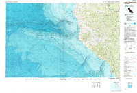
1989 Map of Cape Mendocino
USGS Topo · Published 1989About this map
Humboldt Redwoods State Park and the towering King Range dominate this coastal landscape where the land meets the deep waters of the Pacific Ocean. This topographic-bathymetric study reveals the dramatic transition from terrestrial peaks like Grasshopper Mountain and Taylor Peak to the massive underwater features of the Gorda Escarpment and Mendocino Ridge. Along the shoreline, navigational history is anchored by the Cape Mendocino Lighthouse and the Punta Gorda Lighthouse. Small settlements including Petrolia and Shelter Cove are positioned along the river systems of the Mattole River and Bear River, while the northern edge of the map shows the community of Rio Dell near the Eel River. The map also delineates the Cape Mendocino Coast Guard Reservation, illustrating the strategic importance of this westernmost point of California.
Find a feature on this map
42 named features on this map. Tap any name to fly to it.
Don’t see what you’re looking for? This feature index may not catch every label — zoom into the map to look around manually.
Map Details
Editions of this 1989 Cape Mendocino Map
This is the sole edition of this map. No revisions or reprints were ever made.
Other maps of this area

1916 · Cape Fortunas
USGS Topo · 1:62,500

1919 · Glynn
USGS Topo · 1:62,500

1920 · Pt. Delagda
USGS Topo · 1:62,500

1921 · Dyerville
USGS Topo · 1:62,500

1921 · Briceland
USGS Topo · 1:62,500

1921 · Cape Mendocino
USGS Topo · 1:62,500

1922 · Kneeland
USGS Topo · 1:62,500

1926 · Gorda
USGS Topo · 1:62,500

1943 · Ferndale
USGS Topo · 1:62,500

1944 · Fortuna
USGS Topo · 1:62,500