
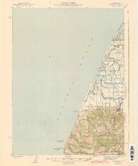
1943 Map of Ferndale
USGS Topo · Published 1943About this map
Ferndale anchors this coastal survey, serving as the cultural and agricultural hub of the lower Eel River delta. The landscape is defined by a complex network of waterways, including the Salt River, McNulty Slough, and Cannibal Island Slough, which weave through the lowlands north of town. This era of Humboldt County history is marked by a high density of rural schoolhouses, such as Eel River Sch and Island Sch, reflecting a distributed community of ranching families. Along the dramatic coastline, Centerville Beach leads south toward the prominent False Cape, while inland, family names are immortalized in landmarks like Russ Ranch and Fern Cottage. The map reveals the vital connection between land and sea, from the grazing lands on Bear River Ridge to the tidal reaches of Humboldt Bay and the South Spit.
Find a feature on this map
61 named features on this map. Tap any name to fly to it.
Don’t see what you’re looking for? This feature index may not catch every label — zoom into the map to look around manually.
Map Details
Editions of this 1943 Ferndale Map
2 editions found
Other maps of this area

1916 · Cape Fortunas
USGS Topo · 1:62,500

1919 · Glynn
USGS Topo · 1:62,500

1921 · Cape Mendocino
USGS Topo · 1:62,500

1922 · Eureka
USGS Topo · 1:62,500

1933 · Eureka
USGS Topo · 1:48,000

1942 · Eureka
USGS Topo · 1:62,500

1944 · Fortuna
USGS Topo · 1:62,500

1949 · Eureka
USGS Topo · 1:250,000

1950 · Cape Mendocino
USGS Topo · 1:62,500

1950 · Scotia
USGS Topo · 1:62,500
Featured Places
- Ferndale, CA
- Port Kenyon, CA
- Arlynda Corners, CA
- Table Bluff Wiyot Reservation / giloulh, CA
- Humboldt County, CA