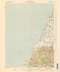
1943 Map of Ferndale
USGS Topo · Published 1943About this map
The Eel River delta and its intricate network of sloughs dominate this 1940s survey of the Humboldt County coastline. The landscape is defined by its transition from the tidal waters of Humboldt Bay and the Pacific Ocean to the fertile bottomlands that support numerous family ranch holdings, such as Russ Ranch and Mayflower Ranch. The presence of several rural schoolhouses, including Island Sch and Centerville Sch, underscores the dispersed nature of these agricultural communities before mid-century consolidation.
Find a feature on this map
50 named features on this map. Tap any name to fly to it.
Don’t see what you’re looking for? This feature index may not catch every label — zoom into the map to look around manually.
Map Details
Editions of this 1943 Ferndale Map
2 editions found
Other maps of this area

1916 · Cape Fortunas
USGS Topo · 1:62,500

1919 · Glynn
USGS Topo · 1:62,500

1921 · Cape Mendocino
USGS Topo · 1:62,500

1922 · Eureka
USGS Topo · 1:62,500

1933 · Eureka
USGS Topo · 1:48,000

1942 · Eureka
USGS Topo · 1:62,500

1943 · Ferndale
USGS Topo · 1:62,500

1944 · Fortuna
USGS Topo · 1:62,500

1949 · Eureka
USGS Topo · 1:250,000

1950 · Cape Mendocino
USGS Topo · 1:62,500
Featured Places
- Ferndale, CA
- Port Kenyon, CA
- Arlynda Corners, CA
- Table Bluff Wiyot Reservation / giloulh, CA
- Humboldt County, CA