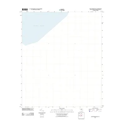
2011 Map of Cape Romain OE E
USGS Topo · Published 2011About this map
The Atlantic Ocean dominates this offshore survey, capturing a specific coastal segment of Georgetown County during the early twenty-first century. As part of the Cape Romain OE E quadrangle, the map focuses primarily on the maritime environment and the marine boundary rather than terrestrial developments. This particular sheet provides a clear spatial reference for the waters just off the South Carolina coast, reflecting the hydrologic data and boundary lines maintained by the U.S. Geological Survey and the National Hydrography Dataset as they stood in 2011.
Find a feature on this map
1 named feature on this map. Tap any name to fly to it.
Don’t see what you’re looking for? This feature index may not catch every label — zoom into the map to look around manually.
Map Details
Editions of this 2011 Cape Romain OE E Map
This is the sole edition of this map. No revisions or reprints were ever made.
Other maps of this area

1942 · Cape Romain
USGS Topo · 1:24,000

1942 · Santee Point
USGS Topo · 1:24,000

1943 · Minim Island
USGS Topo · 1:24,000

1948 · James Island
USGS Topo · 1:250,000

1949 · Georgetown
USGS Topo · 1:250,000

1967 · Georgetown
USGS Topo · 1:250,000
1968 · James Island
USGS Topo · 1:250,000
1969 · James Island
USGS Topo · 1:250,000

1974 · Georgetown
USGS Topo · 1:250,000

1986 · Georgetown
USGS Topo · 1:100,000