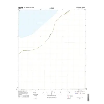
2017 Map of Cape Romain OE E
USGS Topo · Published 2017About this map
The Atlantic Ocean dominates this coastal survey, where the open sea meets the shoreline of South Carolina at a point along the Georgetown County boundary. The only landform visible on this specific sheet is a portion of Cedar Island, appearing in the northwestern corner of the quadrangle. This map represents the outermost edge of the state's coastal marshes and barrier islands, capturing the maritime geography as it existed in 2017. Because this area is primarily open water, the map serves as an important record of the contemporary coastline before shifting tides and environmental changes further alter the boundary between the sea and the coastal islands.
Find a feature on this map
4 named features on this map. Tap any name to fly to it.
Don’t see what you’re looking for? This feature index may not catch every label — zoom into the map to look around manually.
Map Details
Editions of this 2017 Cape Romain OE E Map
This is the sole edition of this map. No revisions or reprints were ever made.
Other maps of this area

1942 · Cape Romain
USGS Topo · 1:24,000

1942 · Santee Point
USGS Topo · 1:24,000

1943 · Minim Island
USGS Topo · 1:24,000

1948 · James Island
USGS Topo · 1:250,000

1949 · Georgetown
USGS Topo · 1:250,000

1967 · Georgetown
USGS Topo · 1:250,000
1968 · James Island
USGS Topo · 1:250,000
1969 · James Island
USGS Topo · 1:250,000

1974 · Georgetown
USGS Topo · 1:250,000

1986 · Georgetown
USGS Topo · 1:100,000