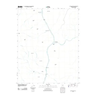
2011 Map of Cape Solitude
USGS Topo · Published 2011About this map
The confluence of the Colorado River and the Little Colorado River defines this landscape in the early twenty-first century, marked by the dramatic drop of the Little Colorado River Gorge. The river corridor is punctuated by navigational landmarks for river travelers, including the churning waters of Sixtymile Rapids and Lava Canyon Rapids. Away from the water, the terrain rises sharply toward massive geological formations like Gunther Castle, Temple Butte, and the high vantage of Cape Solitude. The map details a network of drainage systems such as Chuar Creek and Palisades Creek that have carved deep into the desert floor. This area of Coconino County remains a study in isolation and natural architecture, where features like Desert Facade and Peshlakai Point tower over the Marble Canyon corridor. The geography recorded here reflects the enduring character of the high desert before it meets the river's edge.
Find a feature on this map
36 named features on this map. Tap any name to fly to it.
Don’t see what you’re looking for? This feature index may not catch every label — zoom into the map to look around manually.
Map Details
Editions of this 2011 Cape Solitude Map
This is the sole edition of this map. No revisions or reprints were ever made.
Other maps of this area

1886 · Echo Cliffs
USGS Topo · 1:250,000

1891 · Echo Cliffs
USGS Topo · 1:250,000

1907 · Vishnu
USGS Topo · 1:48,000

1954 · Nankoweap
USGS Topo · 1:62,500

1954 · Shinumo Altar
USGS Topo · 1:62,500

1955 · Blue Spring
USGS Topo · 1:62,500

1956 · Marble Canyon
USGS Topo · 1:250,000

1959 · Marble Canyon
USGS Topo · 1:250,000

1961 · Marble Canyon
USGS Topo · 1:250,000
1962 · Vishnu Temple
USGS Topo · 1:62,500