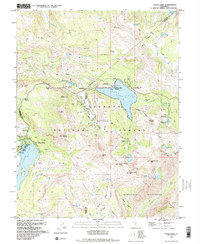
1992 Map of Caples Lake
USGS Topo · Published 1994About this map
Caples Lake and Silver Lake anchor this high-altitude landscape where the borders of El Dorado, Amador, and Alpine counties converge. The region is defined by its transition from a historic thoroughfare to a premier recreation destination, marked by the Old Emigrant Trail Historical Marker near the north shore of Caples Lake. By the early 1990s, the development of Kirkwood Ski Resort and clustered settlements like Kirkwood and Caples Lake Resort stand alongside established summer retreats such as Kit Carson Resort and Kayes Resort. Higher elevations are preserved within the Mokelumne Wilderness, where the Pacific Crest National Scenic Trail winds past alpine waters like Showers Lake and Fourth of July Lake. From the heights of Thunder Mountain to the depths of Dixon Canyon, the map traces a network of camps, campgrounds, and the site of the Lost Cabin Mine.
Find a feature on this map
74 named features on this map. Tap any name to fly to it.
Don’t see what you’re looking for? This feature index may not catch every label — zoom into the map to look around manually.
Map Details
Editions of this 1992 Caples Lake Map
3 editions found
Other maps of this area

1889 · Pyramid Peak
USGS Topo · 1:125,000

1889 · Markleeville
USGS Topo · 1:125,000

1891 · Markleeville
USGS Topo · 1:125,000

1891 · Pyramid Peak
USGS Topo · 1:125,000

1893 · Markleeville
USGS Topo · 1:125,000

1895 · Pyramid Peak
USGS Topo · 1:125,000

1896 · Pyramid Peak
USGS Topo · 1:125,000

1947 · Sacramento
USGS Topo · 1:250,000

1948 · Walker Lake
USGS Topo · 1:250,000

1948 · Sacramento
USGS Topo · 1:250,000