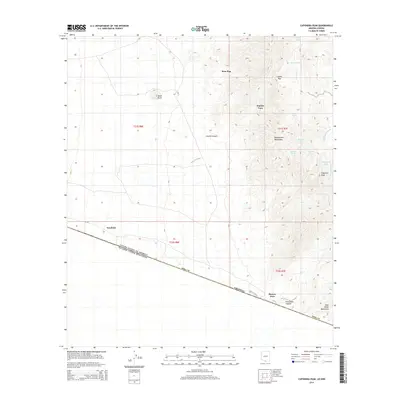
2014 Map of Caponera Peak
USGS Topo · Published 2014About this map
The United States-Mexico border defines the southern reach of this Pima County landscape, where the high ridges of the Baboquivari Mountains meet the desert floor. In this arid environment, human activity and survival are tied to the collection of water, evidenced by a network of named sites such as Coyote Tank, Saguaro Tank, and Antonio Tank scattered across the district. Small settlements like Kom Kug, Sapano Vaya, and Newfield are positioned along the lower elevations, while Buenos Aires sits near the international line.
Find a feature on this map
28 named features on this map. Tap any name to fly to it.
Don’t see what you’re looking for? This feature index may not catch every label — zoom into the map to look around manually.
Map Details
Editions of this 2014 Caponera Peak Map
This is the sole edition of this map. No revisions or reprints were ever made.
Other maps of this area

1941 · Presumido Peak
USGS Topo · 1:62,500

1941 · Vamori
USGS Topo · 1:62,500

1943 · Fresnal
USGS Topo · 1:125,000

1943 · Presumido Peak
USGS Topo · 1:62,500

1943 · Vamori
USGS Topo · 1:62,500

1956 · Nogales
USGS Topo · 1:250,000

1958 · Nogales
USGS Topo · 1:250,000

1959 · Nogales
USGS Topo · 1:250,000
1979 · Sasabe
USGS Topo · 1:24,000
1979 · Mildred Peak
USGS Topo · 1:24,000
Featured Places
- Chukut Kuk District, AZ
- Kom Kug, Chukut Kuk District
- Newfield, Chukut Kuk District
- Sapano Vaya, Chukut Kuk District
- Buenos Aires, Chukut Kuk District