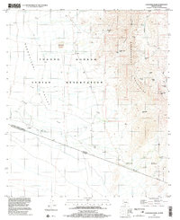
1996 Map of Caponera Peak
USGS Topo · Published 2003About this map
Tohono O'odham Indian Reservation land dominates this borderland landscape, where the Baboquivari Mountains meet the Baboquivari Valley. This late-twentieth-century study documents the intersection of sovereign tribal land and the international boundary between the United States and Mexico. The map details several historic locations, including the ranching settlements of Newfield, Buenos Aires, and Presumido, alongside archaeological or former habitation points like Kom Kug (Site) and Sapano Vaya (Site). The water-scarce environment is defined by its network of tanks and wells, such as Hendricks Well and Coyote Tank, which supported cattle and subsistence in this desert terrain. From the high point of Caponera Peak to the southwestern slopes of the Pozo Verde Mts, the topography reveals a land shaped by the Coyote Wash and significant peaks like Nachi Kulik.
Find a feature on this map
29 named features on this map. Tap any name to fly to it.
Don’t see what you’re looking for? This feature index may not catch every label — zoom into the map to look around manually.
Map Details
Editions of this 1996 Caponera Peak Map
This is the sole edition of this map. No revisions or reprints were ever made.
Other maps of this area

1941 · Presumido Peak
USGS Topo · 1:62,500

1941 · Vamori
USGS Topo · 1:62,500

1943 · Fresnal
USGS Topo · 1:125,000

1943 · Presumido Peak
USGS Topo · 1:62,500

1943 · Vamori
USGS Topo · 1:62,500

1956 · Nogales
USGS Topo · 1:250,000

1958 · Nogales
USGS Topo · 1:250,000

1959 · Nogales
USGS Topo · 1:250,000
1979 · Sasabe
USGS Topo · 1:24,000
1979 · Mildred Peak
USGS Topo · 1:24,000
Featured Places
- Chukut Kuk District, AZ
- Newfield, Chukut Kuk District
- Buenos Aires, Chukut Kuk District
- Sapano Vaya, Chukut Kuk District
- Kom Kug, Chukut Kuk District