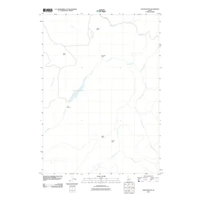
2010 Map of Captain Butte
USGS Topo · Published 2010About this map
Succor Creek Reservoir sits as a central water feature in this arid landscape, held by the Texas Basin Dam at its southern end. The surrounding terrain is defined by high-desert formations and drainage basins, including the broad Texas Basin and prominent elevations like Captain Butte and Flattop Butte. Water management and natural drainage define the area's layout, with Succor Creek and its many tributaries, such as Little Succor Creek and Coal Mine Basin Creek, carving through the high plateau. The presence of Table Rock and Sage Hen Gulch underscores the geographic diversity of this corner of Owyhee County. Remote access is primarily limited to routes like Chipmunk Rd, reflecting the quiet, rural character of this ranching and watershed region in the early 21st century.
Find a feature on this map
16 named features on this map. Tap any name to fly to it.
Don’t see what you’re looking for? This feature index may not catch every label — zoom into the map to look around manually.
Map Details
Editions of this 2010 Captain Butte Map
This is the sole edition of this map. No revisions or reprints were ever made.
Other maps of this area

1892 · Silver City
USGS Topo · 1:125,000

1894 · Silver City
USGS Topo · 1:125,000

1898 · Silver City
USGS Topo · 1:125,000

1955 · Boise
USGS Topo · 1:250,000

1957 · Sands Basin
USGS Topo · 1:62,500

1958 · Boise
USGS Topo · 1:250,000

1962 · Boise
USGS Topo · 1:250,000

1965 · Rooster Comb Peak
USGS Topo · 1:62,500

1967 · Rockville
USGS Topo · 1:24,000
1969 · Hooker Creek
USGS Topo · 1:24,000