1982 Map of Carbondale
USGS Topo · Published 1983About this map
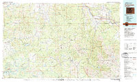
Carbondale and the surrounding river valleys of west-central Colorado are shown here during a period of transition in the early 1980s. The confluence of the Roaring Fork River and the Crystal River serves as a focal point for settlement, with the tracks of the Denver and Rio Grande Western railroad following the water's edge through Satank and Basalt. The industrial legacy of the region is evident in the inclusion of the Black Diamond Mine and Union Mine, which speak to the area's coal and mineral extraction history.
Find a feature on this map
79 named features on this map. Tap any name to fly to it.
Don’t see what you’re looking for? This feature index may not catch every label — zoom into the map to look around manually.
Map Details
Editions of this 1982 Carbondale Map
This is the sole edition of this map. No revisions or reprints were ever made.
Other maps of this area

1888 · Crested Butte
USGS Topo · 1:62,500

1888 · Anthracite
USGS Topo · 1:62,500

1889 · Crested Butte
USGS Topo · 1:62,500

1889 · Anthracite
USGS Topo · 1:62,500

1893 · Anthracite
USGS Topo · 1:62,500

1893 · Crested Butte
USGS Topo · 1:62,500

1893 · Aspen
USGS Topo · 1:62,500

1894 · Anthracite
USGS Topo · 1:62,500

1895 · Aspen
USGS Topo · 1:62,500

1906 · Grand Hogback
USGS Topo · 1:125,000