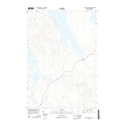
2014 Map of Caribou Lake South
USGS Topo · Published 2014About this map
Caribou Lake and the northwestern reaches of Chesuncook Lake dominate this Maine North Woods landscape, where industrial logging infrastructure intersects a complex network of glacial waterways. The presence of the Golden Rd and Sias Hill Rd highlights the vital role of private hauling routes in accessing this timber-rich interior of Piscataquis County. These unpaved arteries provide the primary modern connection between remote water bodies like Ragged Lake and Big Fisher Pond. The drainage patterns, defined by smaller tributaries such as Ragged Stream and Gulliver Brook, illustrate the challenging terrain that shaped the region's historical logging operations. Collectors and outdoor researchers can trace the routes used to move timber from the highlands surrounding Bear Pond and Otter Pond toward the larger lakes for transport.
Find a feature on this map
21 named features on this map. Tap any name to fly to it.
Don’t see what you’re looking for? This feature index may not catch every label — zoom into the map to look around manually.
Map Details
Editions of this 2014 Caribou Lake South Map
This is the sole edition of this map. No revisions or reprints were ever made.
Other maps of this area

1952 · Jo-Mary Mountain
USGS Topo · 1:62,500

1952 · First Roach Pond
USGS Topo · 1:62,500

1954 · Grant Farm
USGS Topo · 1:62,500

1954 · Harrington Lake
USGS Topo · 1:62,500

1954 · Millinocket
USGS Topo · 1:250,000

1958 · Millinocket
USGS Topo · 1:250,000

1960 · Millinocket
USGS Topo · 1:250,000
1977 · Pine Stream Flowage
USGS Topo · 1:24,000
1977 · Big Spencer Mountain
USGS Topo · 1:24,000
1977 · Kokadjo
USGS Topo · 1:24,000