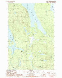
1988 Map of Caribou Lake South
USGS Topo · Published 1988About this map
Grant Farm sits at the center of this Maine backcountry landscape, surrounded by an intricate network of waterways in the late 1980s. The area is defined by the massive presence of Caribou Lake and Chesuncook Lake to the north, which serve as the primary geographical anchors for this section of Piscataquis County. These waters are connected by a system of smaller ponds and streams, including Big Fisher Pond and Ragged Lake, the latter of which features the Ragged Lake Campsite along its eastern shore.
Find a feature on this map
30 named features on this map. Tap any name to fly to it.
Don’t see what you’re looking for? This feature index may not catch every label — zoom into the map to look around manually.
Map Details
Editions of this 1988 Caribou Lake South Map
This is the sole edition of this map. No revisions or reprints were ever made.
Other maps of this area

1952 · Jo-Mary Mountain
USGS Topo · 1:62,500

1952 · First Roach Pond
USGS Topo · 1:62,500

1954 · Grant Farm
USGS Topo · 1:62,500

1954 · Harrington Lake
USGS Topo · 1:62,500

1954 · Millinocket
USGS Topo · 1:250,000

1958 · Millinocket
USGS Topo · 1:250,000

1960 · Millinocket
USGS Topo · 1:250,000
1977 · Pine Stream Flowage
USGS Topo · 1:24,000
1977 · Big Spencer Mountain
USGS Topo · 1:24,000
1977 · Kokadjo
USGS Topo · 1:24,000