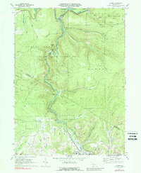
1970 Map of Carman
USGS Topo · Published 1988About this map
The Clarion River winds through the northern portion of this landscape, marking a rugged corridor of industrial and natural transition in the early 1970s. The region is defined by the extraction economy of Elk and Jefferson Counties, where numerous Gas Wells and Strip Mines are interspersed between the protected reaches of the Allegheny National Forest and multiple state game lands. These industrial operations follow the terrain's ridges, particularly around Empire Ridge and Vineyard Point, while the valleys carry the vital transport arteries of the era.
Find a feature on this map
51 named features on this map. Tap any name to fly to it.
Don’t see what you’re looking for? This feature index may not catch every label — zoom into the map to look around manually.
Map Details
Editions of this 1970 Carman Map
3 editions found
Other maps of this area

1922 · Du Bois
USGS Topo · 1:62,500

1924 · Du Bois
USGS Topo · 1:62,500

1929 · Penfield
USGS Topo · 1:62,500

1932 · Penfield
USGS Topo · 1:62,500

1940 · Hallton
USGS Topo · 1:48,000

1941 · Ridgway
USGS Topo · 1:62,500

1943 · Hallton
USGS Topo · 1:62,500

1944 · Du Bois
USGS Topo · 1:62,500

1944 · Ridgway
USGS Topo · 1:62,500

1957 · Warren
USGS Topo · 1:250,000
Featured Places
- Polk Township, PA
- Snyder Township, PA
- Ridgway Township, PA
- Carman, Spring Creek Township
- Horton Township, PA