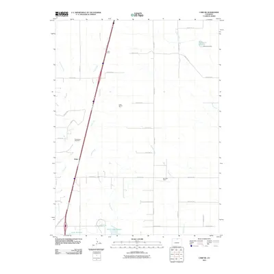
2010 Map of Carr SW
USGS Topo · Published 2010About this map
Indian Creek and Coal Creek define the arid drainage patterns of northern Larimer County in this 2010 survey. The landscape is marked by the infrastructure of ranching and light aviation, centered around the settlement of Bulger and the distinctive Bulger Windmill. Evidence of local industry and recreational use is scattered throughout the quadrangle, from the Indian Springs Mine to the Owl Canyon Gliderport. Water management is a primary feature of the terrain, documented through the Indian Creek Reservoir and its associated Indian Creek Dam, as well as Clark Reservoir to the south. An extensive grid of county roads, including County Rd-110 and County Rd-5, facilitates movement through this high plains environment, while Burnham Field provides another point of aerial navigation in a region characterized by wide-open spaces and intermittent watercourses.
Find a feature on this map
37 named features on this map. Tap any name to fly to it.
Don’t see what you’re looking for? This feature index may not catch every label — zoom into the map to look around manually.
Map Details
Editions of this 2010 Carr SW Map
This is the sole edition of this map. No revisions or reprints were ever made.
Other maps of this area

1906 · Fort Collins
USGS Topo · 1:62,500

1907 · Livermore
USGS Topo · 1:125,000

1908 · Fort Collins
USGS Topo · 1:62,500

1908 · Eaton
USGS Topo · 1:125,000

1909 · Livermore
USGS Topo · 1:125,000

1910 · Eaton
USGS Topo · 1:125,000

1954 · Greeley
USGS Topo · 1:250,000

1957 · Greeley
USGS Topo · 1:250,000

1958 · Greeley
USGS Topo · 1:250,000
1960 · Cobb Lake
USGS Topo · 1:24,000