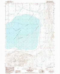
1985 Map of Carson Lake
USGS Topo · Published 1985About this map
The Pony Express Route cuts across this basin in the mid-1980s, tracing a historical line through a landscape dominated by the expansive Carson Lake and Lahon Tan Lake. This area, situated between the White Throne Mountains and the Bunejug Mountains, reflects a desert economy of water management and livestock, evidenced by the large Pasture and remote outposts like Home Corral and Southeast Corral. The terrain is defined by dry lake beds and terminal sinks, including Bass Flat and several Alkali Flats. Industrial activity in this arid environment is captured through modern and traditional resource extraction, including a Geothermal Well, Salt Wells, and the Wildcat Freight Station. The map illustrates the complex drainage patterns and irrigation efforts within the Valley, highlighting the delicate balance of land use in Churchill County.
Find a feature on this map
21 named features on this map. Tap any name to fly to it.
Don’t see what you’re looking for? This feature index may not catch every label — zoom into the map to look around manually.
Map Details
Editions of this 1985 Carson Lake Map
This is the sole edition of this map. No revisions or reprints were ever made.
Other maps of this area

1908 · Carson Sink
USGS Topo · 1:250,000

1910 · Carson Sink
USGS Topo · 1:250,000

1951 · Carson Lake
USGS Topo · 1:62,500

1951 · Allen Springs
USGS Topo · 1:62,500

1951 · Weber Reservoir
USGS Topo · 1:62,500

1951 · Fallon
USGS Topo · 1:62,500

1957 · Reno
USGS Topo · 1:250,000

1959 · Reno
USGS Topo · 1:250,000

1960 · Reno
USGS Topo · 1:250,000

1979 · Fallon
USGS Topo · 1:100,000