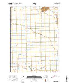
2020 Map of Carson Point
USGS Topo · Published 2020About this map
Carson Point rises as a prominent landmark above the intricate wetlands of Harney County, where the high desert terrain meets complex drainage systems. This 2020 landscape is defined by its water management and natural catchment features, including Cow Creek Sink and the expansive Ninemile Slough. Human adaptation to this arid environment is evident in the straight lines of the Poliade Ditch and a network of remote rural routes like Newton Rd and Crane-Buchanan Rd. The map documents a sparsely populated region of Oregon where ranching life and land use are dictated by the presence of water at Bennett Lake and Howell Lake. Named tracks such as John Logan Ln and Palomino Ln suggest the historical family ties and livestock heritage that continue to shape these vast townships.
Find a feature on this map
29 named features on this map. Tap any name to fly to it.
Don’t see what you’re looking for? This feature index may not catch every label — zoom into the map to look around manually.
Map Details
Editions of this 2020 Carson Point Map
This is the sole edition of this map. No revisions or reprints were ever made.
Other maps of this area

1955 · Burns
USGS Topo · 1:250,000

1958 · Burns
USGS Topo · 1:250,000

1959 · Burns
USGS Topo · 1:250,000

1959 · Harney
USGS Topo · 1:62,500

1959 · Lawen
USGS Topo · 1:62,500

1960 · Crane
USGS Topo · 1:62,500

1973 · Buchanan
USGS Topo · 1:24,000

1973 · Mahon Creek
USGS Topo · 1:24,000

1973 · Carson Point
USGS Topo · 1:24,000
1978 · Stinkingwater Pass
USGS Topo · 1:24,000