
1973 Map of Carson Point
USGS Topo · Published 1977About this map
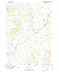
Carson Point rises above an arid Harney County landscape defined by ephemeral water and scattered infrastructure in the early 1970s. The terrain transitions from the high ground of the point down to the seasonal basin containing Bennett Lake and Howell Lake. Water management and resource extraction leave their mark through numerous labeled Well sites and a Drill Hole south of the expansive Sand Dunes. The presence of John Logan Lane in the northeast suggests early ranching or family-named access routes in this part of the state. Drainage patterns are meticulously mapped, showing the relationship between Malheur Slough, Rock Creek, and Little Rock Creek as they negotiate the basin floor. This survey provides a precise look at the land's hydrology and human footprint just before the mid-1970s, from the edge of Crane Creek to the various sand formations.
Find a feature on this map
11 named features on this map. Tap any name to fly to it.
Don’t see what you’re looking for? This feature index may not catch every label — zoom into the map to look around manually.
Map Details
Editions of this 1973 Carson Point Map
This is the sole edition of this map. No revisions or reprints were ever made.
Other maps of this area

1955 · Burns
USGS Topo · 1:250,000

1958 · Burns
USGS Topo · 1:250,000

1959 · Burns
USGS Topo · 1:250,000

1959 · Harney
USGS Topo · 1:62,500

1959 · Lawen
USGS Topo · 1:62,500

1960 · Crane
USGS Topo · 1:62,500

1973 · Buchanan
USGS Topo · 1:24,000

1973 · Mahon Creek
USGS Topo · 1:24,000
1978 · Stinkingwater Pass
USGS Topo · 1:24,000

1978 · Malheur Lake
USGS Topo · 1:100,000