2003 Map of Carter
USGS Topo · Published 2004About this map
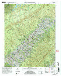
Holston Mountain dominates the landscape in this northeast Tennessee region, where the Cherokee National Forest and the Big Laurel Branch Wilderness protect a complex network of ridges and hollows. Small settlements like Sadie, Housley, and Carter are tucked into the valley floors, particularly along the path of Stony Creek and its many tributaries such as Hodge Branch and Richardson Branch. This area is characterized by a high concentration of family-named landmarks and essential community institutions. Genealogists can trace local heritage through numerous burial sites including Stoutson Cem and Grindstaff Cem, while the presence of the Holston Mtn Fire Tower at Holston High Knob and the Helicopter Waterhole reflect the practicalities of managing these heavily forested slopes. The map also captures local education and industry, from the Unaka Sch to the Stoutson Quarry near Buladeen.
Find a feature on this map
52 named features on this map. Tap any name to fly to it.
Don’t see what you’re looking for? This feature index may not catch every label — zoom into the map to look around manually.
Map Details
Editions of this 2003 Carter Map
This is the sole edition of this map. No revisions or reprints were ever made.
Other maps of this area

1891 · Roan Mountain
USGS Topo · 1:125,000

1891 · Abingdon
USGS Topo · 1:125,000

1893 · Cranberry
USGS Topo · 1:125,000

1894 · Roan Mountain
USGS Topo · 1:125,000

1894 · Abingdon
USGS Topo · 1:125,000

1895 · Cranberry
USGS Topo · 1:125,000

1897 · Bristol
USGS Topo · 1:125,000

1899 · Cranberry
USGS Topo · 1:125,000

1902 · Bristol
USGS Topo · 1:125,000

1902 · Cranberry
USGS Topo · 1:125,000