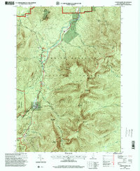
1995 Map of Carter Dome
USGS Topo · Published 2000About this map
White Mountain National Forest dominates this mid-1990s landscape, a region defined by high peaks and specialized recreation. The network of trails and roads centers on the Peabody River valley, where the historic Glen House serves as a gateway to the Mt Washington Auto Road. This era shows a well-established infrastructure for hikers and skiers, with the Appalachian National Scenic Trail traversing the ridgelines from Carter Notch, where the Carter Notch Hut is situated, northward over Carter Dome and Middle Carter Mountain. Large land tracts such as Beans Purchase and Thompson and Meserves Purchase reflect the historic land grant system of the White Mountains. Lowland developments like Dolly Copp and Barnes Field provide evidence of early organized camping and forest management near the Moose River.
Find a feature on this map
54 named features on this map. Tap any name to fly to it.
Don’t see what you’re looking for? This feature index may not catch every label — zoom into the map to look around manually.
Map Details
Editions of this 1995 Carter Dome Map
This is the sole edition of this map. No revisions or reprints were ever made.
Other maps of this area

1893 · Mt. Washington
USGS Topo · 1:62,500

1893 · Gorham
USGS Topo · 1:62,500

1894 · North Conway
USGS Topo · 1:62,500

1895 · Crawford Notch
USGS Topo · 1:62,500

1896 · Mt. Washington
USGS Topo · 1:62,500

1896 · Crawford Notch
USGS Topo · 1:62,500

1896 · North Conway
USGS Topo · 1:62,500

1896 · Gorham
USGS Topo · 1:62,500

1935 · Mt. Washington
USGS Topo · 1:62,500

1937 · Gorham
USGS Topo · 1:48,000